Looking to come check out some CMC campuses with your family in the spring/summer/fall and want to make a vacation out of it? Here's a little guide I threw together!
When To Visit:
May: Called "mud season" in the high rockies, May is one of the last summer months I would recommend for visiting. Skiing has just ended, the snow is all melting, and a lot of the local shops and restaurants shut down until summer arrives. There won't be any hiking to be had, and sight-seeing can be hard because of the stormy weather.
June: You'll miss the beautiful wildflowers at their peak, but a decent amount of the trails have dried up by June. The weather has started to warm up into the high 60's, the local shops reopen, and the crowds are still quiet.
July/August: Absolutely beautiful. Mostly sunny skies, dry temperatures in the low to mid 70's, and wildflowers beyond your wildest dreams.
September: Absolutely beautiful. If you come in early September, it will be a lot like July and August. You won't get to see the wildflowers in their peak as their season will be coming to an end, but the weather will still be beautiful and the traffic won't be nearly as busy. If you come in late September you'll have the pleasure of seeing the changing leaves, which is absolutely breath-taking throughout Colorado. Just be aware that it's not completely unusual for a snowstorm to arrive in late September, so be prepared.
SUNBURN, YEAR ROUND.
At higher altitudes the sun's rays are not filtered as well by the atmosphere, which results in cooler temperatures combined with a significant increase in UVA and UVB intensity. The reflective properties of snow and water only make it worse. This combination is extremely deceptive and potentially dangerous to travelers. Apply sunscreen often and avoid exposure when possible.
Preventing Altitude Sickness
Altitude Sickness is an illness that can affect those who live at low altitudes while visiting high altitudes (typically above 8,000ft) and is due to a combination of reduced air pressure and lower oxygen levels. Symptoms include, but are not limited to, the worst headache of your life (ask me how I know), dizziness, nausea, and a fast heart rate.
*STAY HYDRATED/ENERGIZED: Continuously drink hydrating fluids throughout the day, even if you're not thirsty. Your body is going to be working a lot harder to function at high altitude on top of being in a dry climate, and dehydration can creep up quick.
*TAKE IT SLOW: Allow yourself an entire day to do nothing but relax and let your body adjust to the high altitude. Even an easy hike on your first day can be asking for it.
*AVOID ALCOHOL: One beer at high altitude can be the equivalent of 2-3 beers at sea level. It will be even more so dehydrating and could lead to a vacation-ruining hangover.
*OXYGEN: If you feel the early signs of Altitude Sickness, take a trip to the local oxygen bar or buy a small spray tank of Oxygen at your local convenience store.
Things To Do:
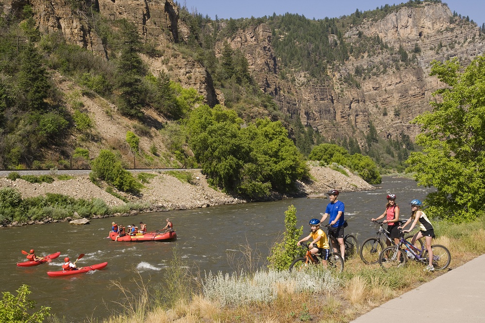
*Rafting/Kayaking: From white-water rafting to lazy rivers in tubes, there are more rafting guides and adventure trips than I can count. You'll be able to find plenty of brochures wherever you plan on visiting.
*Biking: From expert mountain biking to paved road bike paths, there are endless biking opportunities in Colorado. You won't have a problem finding a place to rent bikes either.

*4X4 Tours: Whether it's by SUV or ATV, off-roading is the best way to see Colorado in my opinion. You'll get to see views very few get to see, explore ghost mines and towns, get away from the crowds, see wildlife, get a thrill, and do something that's truly Coloradan.

*Mine Tours: If you're a history buff like myself, I would highly recommend taking a mine tour. There are a couple along I-70 on the way to Summit County from Denver that you'll see. You can take a ride on the historic Loop Railroad between Georgetown and Silverplume (along I-70). You also have the option to take a tour of the Lebanon Silver Mine.
Breckenridge also offers a great tour and some fun activities at the Country Boy mine.
 *Hot Springs: Like hot tubs? Then you'll love the numerous natural hot springs or pools heated by them throughout Colorado, no matter what time of year. I recommend Strawberry Park Hot Springs in Steamboat and Hot Sulfur Springs in Grand County.

If you're feeling a little out-of-whack because of the high altitude, mountain passes are a great way to sight-see without having to hike. Or if you want to hike, there are plenty of spots to stop and do so!
Boreas Pass
 |
| The start from Breckenridge. |
A 20-mile dirt road that starts in Breckenridge and ends in the extremely small town of Como. I highly recommend this pass for it's scenic views and rustic feel. The start and end of the road is narrow with a steep drop on one side. This can be intimidating as it is a two way road, but don't let that discourage you! The dirt road is well groomed with minimal pot holes and the entire drive itself is relativity flat. You will come across a well preserved mine about half way down the road. You will also come across some side roads, but most are private property, so be respectful.
 |
| The town of Como. |
When you reach the end of the road you will have the option to go left to Como or right, travel both routes. The right has some of the most scenic and majestic views you will ever see. Como, to the left, will blow anyone's mind who came from a somewhat civilized town. Please stop and support their few local stores, as they rely heavily on tourist traffic to survive.
*A fun alternate route back would be to take Como to Fairplay, to Alma/Hoosier Pass, see below.
Hoosier Pass
 Hoosier will take you from Breckenridge, through Blue River, to the small town of Alma. It has some fun switchbacks and incredible views of Quandry (14er) and surrounding mountains. There's a place to park at the continental divide to take some pictures. If you have binoculars it's fun to scope Quandry for hikers (you'll spot plenty). If you make it to Alma and want to keep going, you can go to Fairplay (South Park), which is the town the show South Park is based off of.
*A fun alternate route back would be to take Como to Fairplay, to Alma/Hoosier Pass, see below.
Hoosier Pass

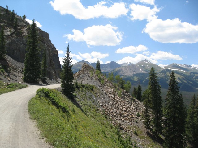
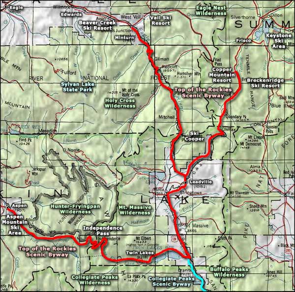
Top of the Rockies Scenic Byway - Copper Mountain to Leadville, Leadville to Vail, Leadville to Aspen (Independence Pass).
If you're coming to visit Summit County, Vail, or Leadville, I highly recommend the Copper Mountain to Leadville to Vail loop. This drive will include the highest peaks in Colorado, abandoned mines, easy to difficult side hikes, and much more. After leaving Copper Mountain towards Leadville, don't forget to stop at Clinton Gulch (covered in the hiking section below), which will be a few miles up the pass on your left. There isn't a whole lot of anything but amazing scenery until you reach Leadville.

Leadville back to Vail is the more epic portion of the drive, but I'm not going to lie, it's not necessarily ideal for the faint of heart. Highlights include the abandoned WWII 10th Mountain Division's Camp Hale (read here), the 470ft long Red Cliff bridge (pictured to the left), the abandoned modern mining town of Gilman (read here), and the small towns of Red Cliff and Minturn.

If you plan on visiting Aspen or want to see some extra scenery, Independence Pass is a must for the thrill seekers. Sections of the pass have a speed limit of 25 mph, with advisory limits on some switchbacks as low as 10 mph. The pass closes after the first big snow fall in autumn, so if you're traveling during early spring or late fall, make sure it's open. And again, portions of this pass aren't for the faint of heart. Click here to download a map of some of the highlights!
Loveland Pass
 |
| Looking down the pass at I-70. |
Loveland Pass is the highest mountain pass in the world that regularly stays open during the winter, mostly because trucks that cannot use Eisenhower Tunnel (hazardous material or too large) must use it as a detour. You'll exit I-70 just before you reach the tunnel and almost immediately see parking for Loveland Ski Area. You'll continue up the winding road until it breaks treeline. This is where it gets a bit sketchy with steep drops on the right side of the road, so use caution. You'll eventually reach the summit, which is also on the Continental Divide, at 11,990ft. There is parking here, so stop and enjoy the scenery!
You'll then begin the drive back down where you'll get an awesome view of the Loveland backcountry and Arapahoe Basin Ski Area in the distance. Pay attention to the road though, there are just as many parking spots along the way as there are hairpin turns and steep drops. Once you come to A-Basin the road gets a bit more mellow and the speed limit rises. If you watch carefully on your right you'll see a pull-off spot for a natural spring, I highly recommend stopping and filling up any water bottles you may have. The "pass" portion of the road ends at Keystone Ski Resort.
Hiking
 |
| Looking down the pass at A-Basin. |
Hiking
*I based my difficulty ratings for someone of average physical fitness living at sea level. They are also based off doing the entire hike. So if you want to do just part of it, it may be less difficult. They're just guidelines though, so hike at your own risk.
TIPS TO A SUCCESSFUL HIKE:
1. WHAT GOES UP, MUST COME DOWN. When I first started doing mountain hikes I was so excited to get to the summit that I would forget I needed enough energy to get back down. Make smart decisions; if you feel any sign of body pain or fatigue, stop and turn around.
2. DON'T DRESS LIKE A TOURIST. Flip flops and skinny jeans aren't going to cut it. Wear comfortable layers. It's going to be chilly early but it's going to warm up quick.
3. THE EARLY BIRD GETS THE WORM. Save the scenic driving for the afternoon, do all your hikes early (sunrise). You will avoid the crowds and the most intense sun rays.
4. WATER AND FOOD, BRING THEM. I can't tell you the amount of times I've been hiking and saw tourists without food or water.
Maroon Bells

Distance: 0 - 6mi
Trail-head Elevation: 7,500ft
Elevation Gain: 0 - 300ft
Difficulty: Easy - Moderate
Entrance Fee: $10
The Maroon Bells (both 14,000ft+) are located in the Maroon Bells-Snowmass Wilderness, and are considered to be the most photographed peaks in Colorado. The lake and views of the Bells are a very short distance from the parking lot, so there really is no hiking required... but there are several trails around the lake that you'll find, all of which are relatively flat and easy to traverse, though there is one trail that is more on the moderate scale. There are actually 30 miles of difficult trails for backpackers, but you won't accidentally wander onto them. (View the details of Maroon Bells here.)
Hanging Lake / Spouting Rock

Distance: 2.4mi round trip
Difficulty: Moderate
Trail-head Elevation: 6,200ft
Elevation Gain: 1,000ft
Entrance Fee: None
This is my most highly recommend destination for those new to Colorado, but do it early on a weekday. The trail itself will kick your butt, so come prepared with the right shoes and plenty of water/snacks. The very last section of the trail before the lake is basically on the edge of a cliff... It has railings, but it still may be scary for those afraid of heights. (View the details I wrote at the end of this entry.)
*The Forest Service actually has this trail rated as difficult. I rated it as moderate because of it's short distance, and because it's a walk in the park compared to a few of the other trails I have on this page.
Continental Falls / Mohawk Lakes

Distance: 6 - 6.8mi round trip
Difficulty: Difficult
Trail-head Elevation: 9,500ft
Elevation Gain: 1,700ft
Entrance Fee: None
I recommend this hike for those looking for a true Coloradan-local hike. You will see everything on this trail from mine ruins, to well-preserved cabins, small lakes, wildlife, and of course... amazing waterfalls! There is lower and upper Continental falls and lower and upper Mohawk Lake. There is also a side hike to Mayflower Lake, I have never been there though, and I've heard it's not much to see. The beginning of the trail starts through thick forest with moderate elevation climbing, it's the last part of the hike that's more intense. If you're in a vehicle with good clearance, there's actually a parking lot quite a bit higher up the trail that will drastically shorten the hike. Message me for details if you plan on doing this hike!
Clinton Gulch

Distance: 0-2mi round trip
Difficulty: Easy
Trail-head Elevation: 11,100ft
Elevation Gain: None
Entrance Fee: None
Clinton Gulch will always have a piece of my heart. It's one of those places that's always really quiet and just so breathtakingly beautiful. There are trails on both sides, though the trail on the left is my favorite because you get a better view (in my opinion).
Baldy Mountain (13,684ft)

Distance: 9.5mi round trip
Difficulty: Extremely difficult
Trail-head Elevation: 10,600ft
Elevation Gain: 3,084ft
Entrance Fee: None
If you really want to climb a mountain, I recommend Baldy because of it's spectacular views and easy accessibility. Us locals who live on Baldy are constantly hiking/driving the mining road and it's a popular mountain for large travel groups to hike. Unfortunately the first 1/3rd of the hike is through thick forest without much scenery, but if you have a vehicle with decent clearance you can drive up and park by the blue mine building (can't miss it). If you're not with a local who knows the mountain well, don't travel off the main road. There are a lot of tempting side trails/roads, but there's a lot of private property and a lot of confusing trail/mining road systems that will get you lost. (View the details of hiking Baldy here.)
Fish Creek Falls

Distance: .5 - 5mi round trip
Difficulty: Easy - Moderate
Trail-head Elevation: 7,440ft
Elevation Gain: -/+ 500ft
Entrance Fee: $5 Seasonal
Fish Creek Falls is a 283ft waterfall with two parking lots, the upper being wheelchair accessible. The view to the left is a short 10 minute walk down a dirt trail from the lower parking lot. You can also continue across the bridge and hike 2.5 miles up to Upper Fish Creek Falls. Apparently there is a $5 fee for parking, but when I went in May a couple years ago there wasn't a fee (maybe because it was mud season). I'm pretty sure there are some other trails in the area to explore as well.